| |
|
| |
| |
 |
| Review any OIC product by selecting it from the menu below |
| |
|
|
 |
| Choose from the dropdown menus below to learn about OIC supported sensor types |
| |
|
|
 |
| Click on the dropdown menu below to find out more about the services OIC offers. |
| |
|
| |
|
|
|
 |
|
|
| Home
» Products
» Devices
» Digital Sidescan Sonars |
|
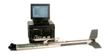
| Datasonics
SIS1500/02 |
| |
The Datasonics SIS1500 series was made by Datasonics,
Inc., which is now a part of Teledyne
Benthos Inc., of North Falmouth, Massachusetts. The SIS-1500
utilizes Chirp Technology in the (190-210 kHz) frequency band
for side scan sonar imagery for swaths up to 1000 meters, with
uniform cross-track resolution. |
| |
 |
| |
For more details on the SIS-1500, click
here. |
| |
OIC supports the Datasonics SIS-1500 sidescan
(digital output) via GeoDAS-PC/1500, providing a full control,
logging and real-time processing solution. Logging the SIS-1500
data as digital OIC records allows post-acquisition processing
and mosaic productions with GeoDAS-Desktop or OICcleansweep.
|
| |
For demo data and example mosaics, please
see our Data Samples
For details on acquisition, see the GeoDAS
section. |
|
|
