
© 2013 Oceanic Imaging Consultants, Inc.

Service + Software for Seafloor Mapping

Software / OIC- Class
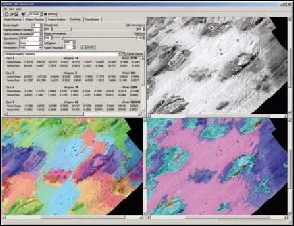
OIC Class is a tool for analysis and classification of sidescan and swath bathymetry data. The program obtains mosaics from OIC’s GeoDAS data acquisition software and STD bitmaps. Data driven image segmentation automatically defines feature boundaries. A “Region Growing” algorithm evaluates the image segment data mean and standard deviation to define natural boundaries of the image and provide superior classification results.

Features and Benefits
- Reads OIC mosaics from GeoDAS or post-processing and STD bitmaps.
- Works with both sidescan and bathymetry.
- Supports user-guided training, plus unsupervised classification.
- Data-driven image segmentation automatically defines feature boundaries.
- The “Region Growing” algorithm evaluates the image segment data mean and standard deviation to help define natural boundaries of the image, providing superior classification results.
- User-selectable features include texture, backscatter, and fractal dimension.
- Unsupervised classification supported by K-means and vector basis functions.
- User-guided supervised training supported by variance-limited Bayesian classifier,
- Help Wizard provides the user with on-the-fly menu and command explanations
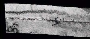
100 Khz sidescan sonar imaging, showing vessel wake.
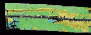
Detection and classification of vessel wake using OIC Class.
Download the
OIC Class Brochure
GeoDAS
GeoDAS-DT
GeoDAS-FLS
GeoDAS-LT
GeoDAS-MB
GeoDAS-MPE
GeoDAS-SDV
OIC-Class
OIC-CleanSweep
OIC-HullSweep
OIC_NAP
OIC_Pipetrack
OIC_Toolkit
OIC_ROVer's Eye
HMS-1400
SAMM